
Cihat Yaycı (29 April 1966) served as commander of the TCG ship Kemalreis between 2005 and 2006. In 2011-2012, he became the Commodore of the 5th Destroyer Flotilla and was promoted to Commodore on 30 August 2012. being appointed military advisor to Moscow that same year. He assumed the functions of Commander of Task Force South and Director of the Multinational Maritime Security Center of Excellence in 2014 and Commander of the Multinational Joint Warfare Center in 2015. On July 29, 2016 he became Rear Admiral. Yaycı, who was appointed Chief of Staff of the Naval Forces Command in the same year, was appointed Chief of Staff of the Naval Forces Command on August 20, 2017 until May 7, 2020. He is also the highest exponent of the Turkish maritime theory of the Mavi Vatan.
Otralectura.com has been able to interview him to learn about the reality of maritime security in the Mediterranean, Libya and the current conflict in Yemen.
Here this interview in spanish [Click here]
- Mavi Vatan, Türkiye and the conflictivity of sea and the protection of land conflicts in the Sea?
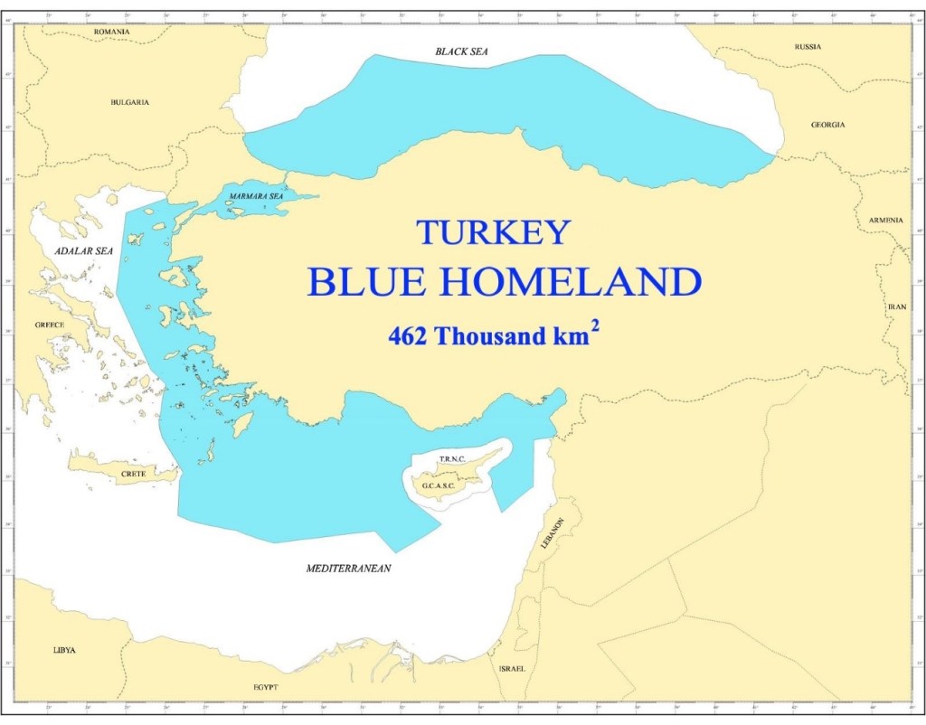
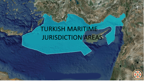
“Mavi Vatan- Blue Homeland” represents the current and envisaged Turkish Maritime Jurisdiction Areas. It is a term not only accepted by the Turkish public but it is also accepted and respected by the global public. The existing or foreseen to be declared maritime jurisdiction areas of Turkiye are positioned on the surrounding seas of Turkiye and the Marmara Sea. The sum of all the maritime jurisdiction areas are defined as “Turkish Maritime Territory (Blue Homeland)”. In general, according to maritime law the status of the seas surrounding Turkiye are under either the enclosed or semi-enclosed sea status.
What Blue Homeland demands is nothing other than the just rights of the Republic of Türkiye which is fully convenient with international law. Blue Homeland plan requires jurisdiction areas which offer each and every neighboring state a quite profitable jurisdiction area agreement which is surely more than what Greece and GRNC offers so that Mavi Vatan never leads to a conflictivity in the region but eases the formation of a just jurisdiction area sharing in the Eastern Mediterranean.
- What is the Mavi Vatan theory and how does it affect the current configuration of the territorial waters of the Eastern Mediterranean Sea? We know this theory as a big opposition in Greece and Cyprus specially, why?
Türkiye’s present or potential maritime jurisdiction areas are strategically located in the seas surrounding Turkiye and the Marmara Sea. The essence of Blue Homeland’s objectives lies solely in securing the just rights of the Republic of Türkiye, aligning seamlessly with international law. The Blue Homeland plan necessitates jurisdictional zones that present highly advantageous agreements to every neighboring state, surpassing what Greece and GRNC currently offer. Generally, according to maritime law, the status of the seas encircling Turkiye falls under either enclosed or semi-enclosed sea classifications. «Blue Homeland» signifies the existing and anticipated Turkish Maritime Jurisdiction Regions. This term finds approval not only within the Turkish populace but also garners recognition and esteem globally. This approach ensures that Mavi Vatan does not contribute to regional conflict but facilitates the fair sharing of jurisdictional areas in the Eastern Mediterranean. The collective expanse of these jurisdictional areas is denoted as the «Turkish Maritime Territory (Blue Homeland).”
In the public domain, the Blue Homeland Doctrine is perceived as an opposition to the Eastern Mediterranean stance of Greece and Greek Cypriot Administration of Southern Cyprus (GCASC). However, Greece’s claim to maritime jurisdiction in the Eastern Mediterranean is not based on the claim that its islands have a continental shelf or exclusive economic zone (EEZ) separate from the mainland. On the contrary, the claims of Greece and the GCASC are based on the assumption that Greece is an archepelogic state. Therefore, the discussions on Greece’s demands regarding the Eastern Mediterranean is quite obsolete.
Unfortunately, Greece’s thesis is not understood by the world, and that there is a lack of knowledge about how Greece’s thesis is against international law and the law of the sea. Greece bases its claim to maritime jurisdiction in the Eastern Mediterranean not on the fact that its islands have a separate EEZ, but on the claim that it is an archipelago state consisting only of islands like Japan, the Philippines and Indonesia. In other words, it claims that the national border is the line connecting its outermost islands and that the measurement of maritime jurisdiction to be made from this line. During the negotiations for the 1982 UN Convention on the Law of the Sea, Greece insisted that it should be considered as an archipelagic state like Japan, the Philippines and Indonesia, and even interrupted the negotiations for this reason, but could not get anyone to accept this claim.

Greece is a peninsular state with islands. Like Italy, Croatia, France. Its islands are not more than 200 miles from the mainland, which is the distance of the continental shelf. The islands belonging to Greece are located within the continental shelf of the mainland of two countries (mainland Turkey and mainland Greece). It is contrary to logic and the legal principles of «the supremacy of geography» and «not blocking the mainland» for the islands located in the continental shelf of the mainland to develop a separate continental shelf and exclusive economic zone.
As can be seen in the map below, even the widest area in the Aegean (Adalar) Sea is 200 nautical miles away. In other words, the center line passes through 100 miles. In this case, the islands are on the continental shelf of either Turkey’s or Greece’s mainland. Within this framework, the starting point of the maritime delimitation of Greece must be the Greek mainland.
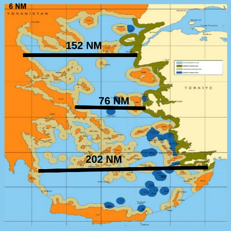
Is the distance of mainland Greece from the (GCASC) and Egypt sufficient to conclude a maritime delimitation agreement? In other words, is the distance between them less than 400 miles? Because the Exclusive Economic Zone of each state can extend up to a maximum distance of 200 nautical miles, if the distance between the mutual coasts is more than 400 miles, they will not be close enough to make a delimitation and therefore they will not be able to conclude an agreement. This is exactly the case for Greece in the Eastern Mediterranean. The distance of the Greek mainland to the island of Cyprus is 458 nautical miles, while the distance to Egypt is 472 nautical miles. That is to say, Greece is not in a geographical position to make an agreement with either the GCASC or Egypt.

Overall, , it should be underlined that Greece’s claim to maritime jurisdiction in the Eastern Mediterranean is not based on the claim that its islands have a continental shelf or exclusive economic zone (EEZ) separate from the mainland.
Therefore, the discussions in Turkey regarding Greece’s demands regarding the Eastern Mediterranean and the map of the University of Seville, which wants to confine Turkey to the Gulf of Antalya, such as «whether the islands in the Eastern Mediterranean and the Adalar (Aegean) Sea have a separate continental shelf or exclusive economic zone, and whether it is incompatible with equity to demand a maritime jurisdiction area 40,000 times the land area of a tiny island like Meis Island» are completely futile. Not only do these discussions harm our national rights and interests, but they are also a clear indication that Greece’s thesis is not understood by Turkey and that we lack knowledge on maritime law, maritime politics and strategies.
Here, Greece, contrary to the rules, principles and principles of the law of the sea that have become customary law and contrary to the definition of archipelagic state in UNCLOS, imposes the acceptance of itself as an archipelagic state by Turkey and other littoral states, and beyond claiming rights in the Eastern Mediterranean, it demands almost 25% of the Eastern Mediterranean.
How?
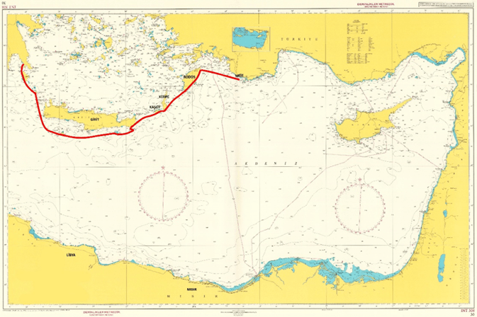
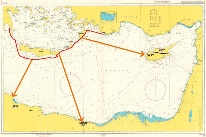
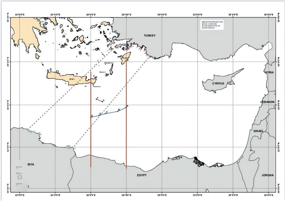
As can be seen in the map below, Greece, assuming that it is an archipelagic state, asserts that the border line of its country in the Eastern Mediterranean is the line connecting MEIS-RODOS-KERPE-KAŞOT-GIRIT-GAVDOS-Small Trough-Large Trough- MORA Peninsula.
This claim has two consequences;
1. The waters to the north of this line are archipelagic waters, i.e. the internal waters of Greece, and therefore Turkey has almost no territorial waters(note that in the Seville University Map, Turkey is not even recognized territorial waters in a significant part of the Adalar (Aegean) Sea).
2. To have rights in the Eastern Mediterranean by ensuring that maritime jurisdiction measurements and agreements (with Egypt, SCGA and Libya) are made from this line instead of Greece’s mainland.
As a result, Greece is not an archipelagic state, nor is it legally and geographically in a position to be taken as an interlocutor for maritime jurisdiction sharing in the Eastern Mediterranean.
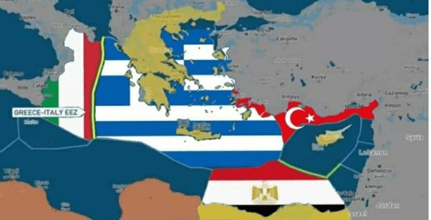
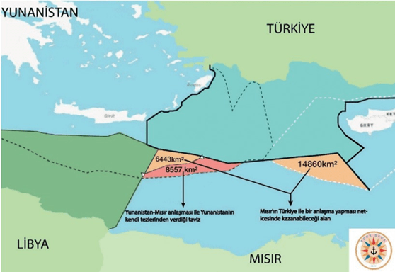
Unfortunately, Egypt, partially accepting Greece’s claims that it is an archipelagic state, signed a maritime delimitation agreement in August 2020 based on the line between Rhodes and Crete as the Greek national border and suffered a great loss.
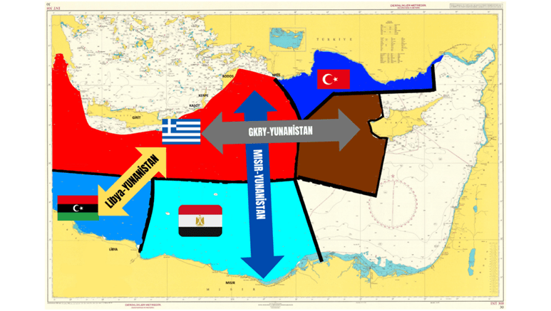
In the Eastern Mediterranean, it is very important to correctly identify the relevant littoral states with which Turkey can make maritime jurisdiction delimitation.
Due to Turkey’s geographical position, it would be the appropriate course of action for Turkey to legally declare its EEZ by taking Libya, Egypt, Palestine, Israel, Lebanon, Syria and the TRNC as interlocutors and to confirm the declared EEZ borders by signing maritime delimitation agreements.
Ultimately, the following map should be presented to show the maritime jurisdiction that Turkey should have in the Eastern Mediterranean in accordance with international law.
- How affect the possition of Greece and Cyprus to the sea security of Türkiye?
The position of Greece and the GCASC is not a sea security against solely Türkiye but it is against the sea security of the whole region. Peace and stability in the region depends on the just and coherent maritime juristiction area sharing in the Eastern Meditarrenean. The unjust demands of Greece and the GCASC are not compatible neither with the international law nor with justice in maritime juristiction sharing. Greece’s demans in the Eastern Mediterranean are based on its invalid assumption that it is an archipelago state. An archipelago state refers to a country or political entity that consists of a group or chain of islands scattered over a body of water such as Indonesia, The Philippines and Japan. Archipelago states do not have a mainland but their surface area consists of islands. Depending upon such an invalid assumption, Greece measures its maritime jurisdiction areas from the outer sea borders of the islands, according to international law, the measurement is supposed to be made from the borders of the mainland. Thus, the incoherent claims of Greece and GCASC lead them seek quite unlawful, unjust demands from Türkiye with regard to exclusive economic zone, flight information region, territorial waters, EGAYDAAK issues. Moreover, in line with the same assumption, they demand excessive maritime regions in comparison to the ideal measurements from the other coastal states.
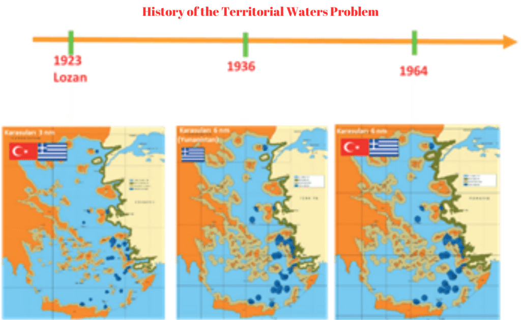
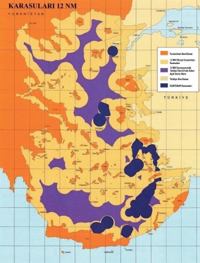
On the other hand, Greece aims to increase its territorial waters to 12 miles illegally. Although there is no concrete provision on the width of the territorial waters in the Lausanne Peace Treaty, it is seen from the paragraph 2 of Article 6 and the last sentence of Article 12 of the Treaty and the practices of the contracting states at that time and their attitudes at the conference that they acted with the understanding that the territorial waters should be 3 nautical miles wide.
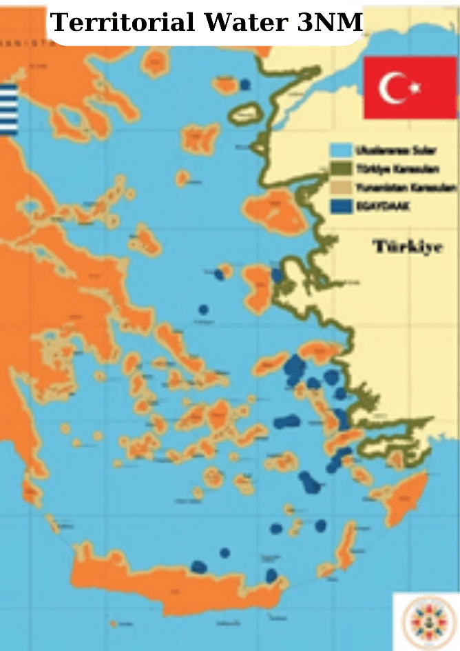
Greece «unilaterally» extended its territorial waters to 6 nautical miles on September 17, 1936. Turkey did not object to Greece’s increase of its territorial waters to 6 nautical miles by violating the Lausanne balance due to the political conjuncture at that time67.
25% of the Adalar (Aegean) Sea into its sovereign territory. Turkey, on the other hand, responded to this action of Greece by declaring that its territorial waters in the Adalar (Aegean) Sea were 6 nautical miles with the Law No. 476 on Territorial Waters enacted in 1964. Thus, the Lausanne Peace The open sea area, which was 71% under the Treaty, decreased first to 49.8% in 1936 when Greece unilaterally increased its territorial waters to 6 nautical miles and then to 48.8% in 1964 when Turkey increased its territorial waters to 6 nautical miles. In this sense, the Lausanne balance was disrupted.
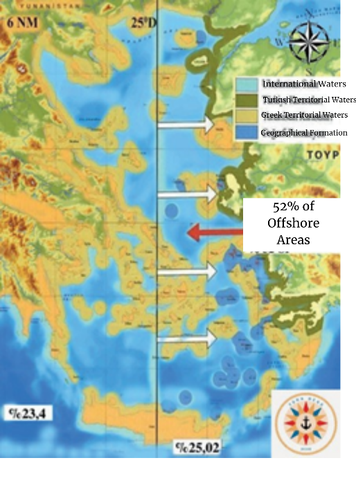
According to the 6 nautical mile wide territorial waters applied today, approximately 39.2% of the Adalar (Aegean) Sea is covered by Greek territorial waters- 39,2%, 12.4% of the Turkish territorial waters 5% of which belongs to the Adalar (Aegean), Islets and Rocks not transferred to Greece by Treaties (EGAYDAAK). The offshore area of the Adalar (Aegean) Sea is 48.4%. For Turkey, the area east of 25 degrees longitude is important for continental shelf delimitation. This region constitutes 25% of the entire maritime area of the Adalar (Aegean) Sea and 52% of the offshore area
Greece, which increased the width of its territorial waters to 6 miles in 1936 by breaking the Lausanne balance, now wants to increase it to 12 miles and turn the Adalar (Aegean) Sea into a Greek lake. If Greece finds favorable conditions and increases its territorial waters to 12 miles, the ratio of open sea areas in the Aegean will decrease to approximately 20% without taking into account the EGAYDAAKs, while Turkey’s territorial sea coverage will increase to 8.7% and Greece’s to 61%.
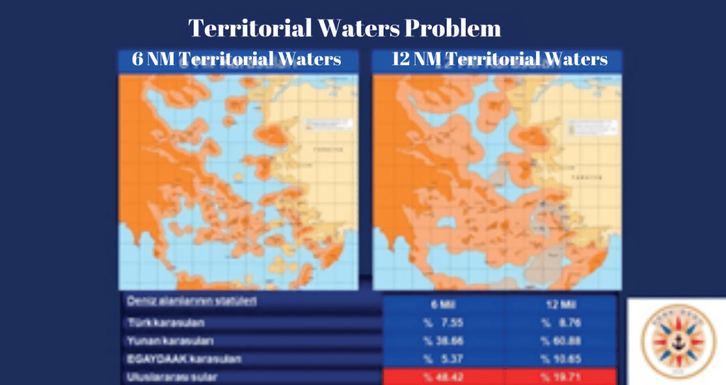
In terms of continental shelf sharing, Turkish territorial waters in the eastern Aegean would increase by 17%, Greek territorial waters by 60%, and offshore areas would decrease by 64% to 9%. Thus, the Adalar (Aegean) Sea would become a Greek inland sea, with the exception of two offshore areas surrounded by Greek territorial waters in two different parts of the Aegean.
Greece refers to the 1982 United Nations Convention on the Law of the Sea (UNCLOS), which recognizes that the maximum limit of territorial waters can be 12 miles, and wants to extend its territorial waters to 12 miles in the Adalar (Aegean) Sea. Turkey, on the other hand, emphasizes that it is not a party to this convention, underlines that the Adalar (Aegean) Sea is a semi-enclosed sea, and states that the principle of equity should be applied when determining the boundary.
While Article 3 of the 1982 UNCLOS grants states the right to determine a territorial sea width of up to 12 nautical miles, it does not dictate 12 nautical miles in absolute terms, and it reveals the existence of situations in which the territorial sea should be less than 12 nautical miles68. On the other hand, with Article 123 of the convention, the Adalar (Aegean) Sea, which has the status of a semi-enclosed sea
It is also stated that general rules cannot be applied for Denizi. Article 300 of the UNCLOS prevents Greece from unilaterally expanding its territorial waters with the provision that «States Parties shall fulfill in good faith the obligations undertaken under the provisions of the present Convention and shall exercise the rights, powers and freedoms granted in a manner that does not constitute an abuse of the right» . Turkey, on the other hand, has not signed UNCLOS. While this is a serious obstacle for Greece, it is also an advantage for Turkey because Turkey is not a party to the convention and is a persistent objector to some of its provisions. Therefore, the provisions of the convention are not binding for Turkey. On June 8, 1995, Turkey declared its determination to protect its rights and interests in the event that Greece extends its territorial waters beyond 6 nautical miles69. The above-mentioned declaration is not a casus belli (an act of war) or a declaration of war within the framework of Article 92 of the Constitution70 . However, the Republic of Turkey has clearly declared to the international public in advance that it will take all kinds of measures to protect its rights and interests arising from international law. In this context, Turkey does not have any territorial demands from Greece, but Greece has continuous demands from Turkey. Greece’s demand for the extension of its territorial waters concerns not only Turkey but also every state that uses the Adalar (Aegean) Sea as an international waterway.
In fact, according to the 6-mile regime in the Adalar (Aegean) Sea, a 1-mile increase in territorial waters would result in a 12% decrease in offshore areas, while in the Eastern Aegean, Turkish territorial waters would decrease by 5.2%, Greek territorial waters would increase by 13%, and offshore areas, which constitute 25% of the entire Aegean, would decrease by 14% to 21.5%.
Any expansion above 6 nautical miles must be done with Turkey’s consent and in a way that does not close Turkish shipping to international shipping. If Greece extends its territorial waters to 12 nautical miles in the Aegean Sea, the following developments are likely to occur:
– States using the Aegean Sea would have to apply the rule of harmless passage and its implications.
– Turkey would lose the possibility of access to the high seas. In such a situation, Turkish ships would have to navigate through Greek territorial waters to transit from the Mediterranean to the Black Sea.
– The Adalar (Aegean) Sea will become a closed Greek Sea.
– With the extension of the territorial waters, Turkey will be completely deprived of its interests in the Aegean Sea.
– The extension of the territorial waters will harm not only Turkey but also international maritime law.
– If the territorial waters are extended, the continental shelf problem will be solved completely against Turkey (Yaycı, 2020a, p. 100).
Greece’s extension of its territorial waters to 12 nautical miles is essentially due to Greece’s policy of unilateral and unlawful extension of its territorial waters. The effect of increasing the territorial sea to more than 6 nautical miles would result in Turkey’s complete isolation from the Adalar (Aegean) Sea and the global maritime space. This would render Turkey virtually unable to breathe.
In fact, at this point, it is necessary to return to the balance established in Lausanne. Turkey, which has experienced three strategic breaks in 1923, 1936 and 1964, has absolutely no tolerance for a fourth break.
- In Black Sea how affect the conflicts arround the coast like the Abkhazia conflict and, of course, the war of Ukraina? Were adalot about the “Montreux Convention Regarding the Regime of the Straits” to put Türkiye as a very important indirect actor in this war for the Turkish straits to connect Black Sea with Mediterrane an what this conflicts means for Turkish security sea and Mavi Vatan?
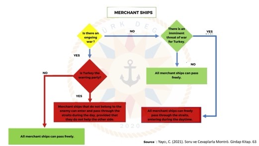
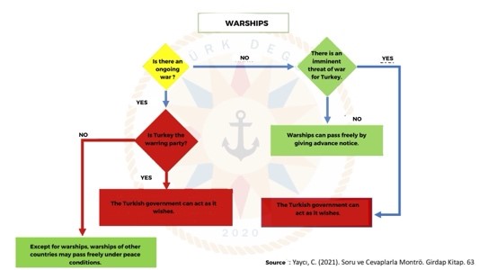
The Montreux Convention, by establishing a very sensitive and fair balance militarily between the Black Sea littoral and non-coastal states, protects the interests of all interested parties and thus ensures peace and stability for the region and makes a significant contribution to the security of the Black Sea coastal states. The Montreux Convention played a key role in ensuring Turkiye’s neutrality during the Second World War, just as it does today. The Montreux Convention has numerous parties one of which is Türkiye. Türkiye is not a party of the conflict between Ukraine and Russia. Moreover, Türkiye has declared its exclusive economic zone in the Black Sea in 1986 and signed agreements with the coastal states consequtevely. Thus, the conflict does not negatively influence Türkiye in neither Black Sea not in the Mediterranean. On the contraty, becuase Türkiye consistently keeps its neutral stance, it has a rare capability in the region as a neutral state which can take the mediator role between the two parties in the peace negotatiation as has achieved the grain corridor in 2023 based on an agreement among three states fort he export of Ukranian grain.
- Türkiye carried out, with you as one of its leaders, agreements in 2019 with Libya which the Goverment of the House of Representatives suspended in 2021 but in 2022 a preliminary energy exploration agreement was signed. Was it a success for Turkish diplomacy to can adapt the Ankara position to the new reality with the 2021 reunification maintaining his interests?
Türkiye and Libya has signed a MOU- Memorandum of Understanding on the delimitation of maritime jurisdiction areas between Türkiye and the legitimate government of National Accord of Libya headed by Fayez El Sarraj on 27 November 2019. According to the Constitution of Libya State, the approval of the Libyan Parliament is not required for an MOU to be signed. Fort hat reason there is no problem about the validity of the MOU signed between Türkiye and Libya. Both the maritime limitation and the exploration agreements are significant successes for the diplomacy of two states but indeed Türkiye and Libya has quite a long past of collaboration. Türkiye has a significant principle about establishing collaborative relations with other states which is to never embrace a imperial-like position but prioritizes equal, win-win collaborative relations. Therefore, I should underline it that the agreements between Libya and Türkiye carry such win-win features which prioritizes the interests of both the states.
- Do you think the sewater agreements between Türkiye and Libya can help to maintain a safer Eastern Mediterranean by helping to stabilize the maritime situation and replace or soften the European Union’s IRINI operation?
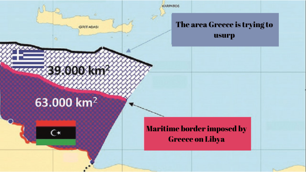
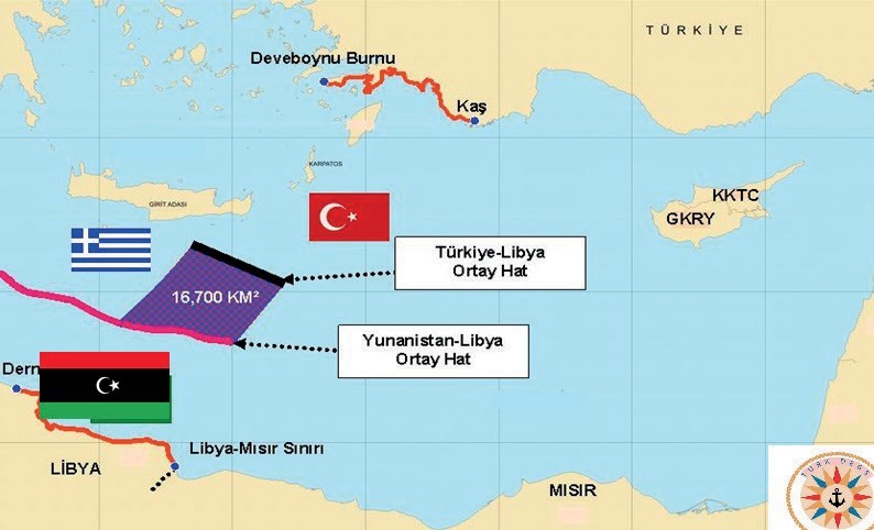
With the Maritime Jurisdiction Delimitation Memorandum of Understanding signed between Libya and Türkiye on 27 November 2019, Libya gained a maritime jurisdiction area of 16,700 km² compared to the map imposed by Greece and paved the way for gaining at least 39,000 km² in total if it signs agreements on the same principle. Unlike the delimitation agreements signed by the GCASC with other coastal states in the Eastern Mediterranean, this treaty complies with the principles of equity, supremacy of geography, proportionality and non-closure of the international law of the sea. From that perception, this agreement is a significant example of how a just and valid could be signed among coastal states in the Eastern Mediterranean to establish stability in the region.
On the other hand, Operation IRINI which was a naval operation launched by the European Union (EU) on 31 March 2020 was criticized by Türkiye based on the fact that the operation was based on UN Security Council Resolution 2292 and that it was launched without the approval of the GNA, despite the fact that this resolution requires consultation with and permission from the Government of National Accord (GNA), which is considered as the legitimate government.
Türkiye clearly sees that the operation has undermined the political process and the ceasefire agreement in Libya, and that it involved unjustified and unlawful interference with Turkish vessels. Türkiye conducts a stable and constructive process with the United Nations-recognised government in Libya.
- Libya is a strategic scenario for Turkish security and maritime space, but apart from this, how is the Turkish role in Libyan land territory projected apart from diplomatic action? General Michael Langley, Commander of AFRICOM, pressured Khalifa Haftar to expulse Wagner Group but to keep the Turkish troops deployed in Libya, especially after the incident with the House of Representatives that wanted to expel the Turkish troops and his allies from Libya. Ankara responded that their presence was legal due to the agreements with the previous government, from which the new national unity government emerged, so the presence was legal and supported by an international agreement. My question is what do theseTurkish troops represent in Libyan territory and how do they defend Turkish strategic interests in Libya and what this troops represent for the Mavi Vatan and Turkish Blue Homeland Sea Theory?
Türkiye and Libya have rooted historical and cultural ties. They historically support each other in hard times. Gazi Mustafa Kemal Atatürk- the founder of Türkiye has lost one of his eyes while defending Libya against occupier forces. Moreover, Libya has given unforgettable support when Türkiye had to make a peace operation to Cyprus when the Turkish Cypriots were massacred by Greek and Greek Cypriot forces in 1974.
When the intervention operations led to be left in a chaotic situation in Libya, Türkiye voluntarily and with the demand of Libyan government, has taken part to give military advisory. Unlike the other forces, the Turkish troops in Libya has been to Libya in response to the demand of the Libyan government. Moreover, they do not take part in militarial operations but they give Professional advisory to the host country as the largest actively fighting armed forces of European continent. Thus, the Turkish troops do not defend the Turkish strategic interests in Libya but they keep their presence in the territory to provide peace, stability and order as well as security to the state by providing advisory. This presence might indirectly servet he maintenance of the Blue Homeland Project by providing maintenance for the peace, stability and security in the region which additionally serves the other coastal states as well.
- What is the objective of this diplomatic projection of Türkiye towards the Maghreb? in what way does this master piece of Turkish diplomatic engineering defend Türkiye´s naval and land interests in Libya?, What geopolitical path does this have in the longterm?
The aim of Türkiye’s diplomatic projection towards the Maghreb could be summarised as follows: to promote peace, stability, cooperation and development in the region, to strengthen Türkiye’s historical and cultural ties, to increase Türkiye’s regional and global influence, and to protect and promote Türkiye’s interests as well as regenerating the historical ties with these countries.
Türkiye is not only present and active militarily in the region, but also intensifies its economic and soft power globally in most of the regions within which it has had historical influence. Türkiye has increased its embassies in Africa from 12 in 2009 to 43 in 2021. The direct investment of Türkiye in Africa accelerated from $100 million in 2003 to $6.6 billion in 2021. Its exports to Africa have increased by 291.3 percent between 2005 and 2020, making it the country with the highest increase in exports to the African continent after China.
Türkiye’s bases its African policy on the principle of «eye-level» relations between equals, as opposed to the relations established by the West for centuries on the principle of «slave-master» understanding. Türkiye is a member of both NATO and the Organisation of Islamic Cooperation and seeks to improve its relations with both the West and the East in balance. Türkiye takes diplomatic initiatives to find solutions to the problems in its region, provides humanitarian aid and successfully carries out peacekeeping missions.
Libya- historically known as Tripolitania- became a part of the Ottoman Empire in 1551 and remained under Ottoman rule for four centuries. Libya was invaded by Italy in 1911, but the local people showed loyalty to the Ottoman Empire and resisted the Italian occupation. During the First World War, the Ottoman Empire provided military and political support to the legitimate government in Libya and regained control in many parts of Libya. When the Armistice of Mondros was signed, Libya became the last territory of the Ottoman Empire in the Mediterranean.
Libya has maintained close relations with Türkiye after gaining its independence in 1951. Libya has contributed to Türkiye’s solution to the security and stability problems in the region and paved the way for Turkiye to increase its cooperation with the countries in the region in economic, political, military, cultural and humanitarian fields. Libya has also helped Turkiye to establish a balance between competition and co-operation with global actors in the region.
Since 2011, Turkiye has provided military and political support to the Government of National Accord (GNA), the legitimate government in Libya, defending Libya’s territorial integrity, sovereignty and democratisation process. Turkiye, by signing a maritime jurisdiction agreement with Libya in 2019, secured the maritime sovereignty and access to hydrocarbon resources of Libya in the Eastern Mediterranean. With its agreement with Libya, Türkiye has made a move against the anti-Turkiye and anti-Libyan initiatives of other countries in the region.
Libya is a strategic partner and ally to protect and promote Turkiye’s and the region’s security in the region. By strengthening its relations with Libya, Turkiye supports peace, stability, cooperation and development in the region. Through its relations with Libya, Turkiye strengthens its historical and cultural ties, improves its relations with other countries in the region, finds solutions to security and stability problems in the region, and balances competition and cooperation with global actors in the region.
- As an Admiral, with a life focus on the sea, do you believe that the maritime as sault activities of Ansarullah of Yemen in the Gulf of Aden and Bab el Mandeb are justified or are they simple acts of piracy? What interests do these activities respond to? Do you think that EUNAVFOR’s Atalanta operation will be expanded after the emergence of Ansarullah members?
Since the Ansarullah armed group is in question, it is not possible to reduce this issue to simple maritime piracy. Ansarullah is the armed wing of the Houthi movement in Yemen. The Houthis are a political and religious movement representing part of the Zaidi Shiites living in northern Yemen. The Houthis have received ideological, cultural and military support from Iran since the 1990s. Houthi-Iranian relations are one of the most important dimensions of the civil war in Yemen. Iran uses the Houthis to increase its influence in Yemen and to consolidate its control over the Red Sea area. Especially as of 7 October 2023, Ansarullah’s activities in and around the Red Sea have become more critical. Ansarullah has between 10,000 and 30,000 militants in Yemen. When we evaluate it from a political, economic and military point of view, of course, this activity of Ansarullah is not a simple sea piracy. There is a multi-dimensional and multi-actor situation here.
From a strategic point of view, these sensational activities of the Iran-backed Ansarullah pave the way for the US and other Western centres to intervene in the region. The US and other extra-regional actors are expanding their intervention area in the region by using these activities carried out by both Iran and the Iranian-backed Ansarullah as a pretext. On the other hand, Iran expands its own sphere of influence and creates a mutual balance with the US. In this conjuncture, EUNAVFOR ATALANTA and many other focal points will expand their activities in the region or seek grounds for expansion.
Houthis has made a statement about their attacks that they only target Israel-linked ships in the Red Sea. They launched a series of attacks which were reflected in the press. However, indeed it seems that there have not been so serious incidents that would give the impression of a very serious threat. But this situation has been exaggerated. The issue is exaggerated to justify a military presence in the region. With this justification, the ground is being created for the presence of other powers, especially the USA and the UK, in the Red Sea in the Sudan and Yemen region. It would not be absurd to say that Iran is opening space for the US, Britain and Israel. However, the presence of the US and the UK here may soon lead to the presence of NATO, and when NATO is present, the presence of EUNAVFOR respectively. Thus, there will be military pressure and influence on the region from both Iran and the US, the UK and, of necessity, the EU. Personally, I think that it would be wrong to think that organisations such as the Houthis or Al Shabaab do not act alone, and that it would be wrong to think of them solely as Iranian-backed groups. Iran and the West protect and develop each other’s interests and have a presence in the region by justifying each other without directly harming each other. In other words, it should be kept in mind that groups such as Al Shabaab or the Houthis can be used and manipulated by any power with interests in the region.
- How would you rate the danger posed by the increase in these pirate activitie so both sides of the Bab el Mandeb Strait, with pirate bases in Somalia and Yemen? Are the yan acceptable risk for the flow of global trade? Does this pose a risk for the troops of Operation Atalanta deployed in the region, among which there are Spanish ships?
Piracy activities in Somalia and Yemen pose a significant threat to EUNAVFOR ATALANTA. These activities are characterised by criminals taking control of vessels sailing in high-risk areas in the region and demanding ransom money for crew, ship and cargo. Operating in the region since 2008, EUNAVFOR ATALANTA monitors fishing activities off the Somali coast, supports other EU missions and international organisations working to strengthen maritime security and capacity in the region, protects World Food Programme (WFP) vessels and other vulnerable vessels carrying aid to Somalia, and deters, prevents and suppresses piracy and armed maritime banditry.
Piracy activities in the region cause serious damage to global trade. Piracy causes ships to change their routes and cause delays, reducing losses in the the volume and revenue of international trade. For example, it is estimated that nearby countries such as Egypt and Yemen lose at least $1.25 billion a year in trade revenues.
This dangerous situation creates deep crises and risks not only in economic terms but also, above all, in the field of security.
For that reason, the defence and economic cooperation deal between Somalia and Türkiye is crucial to provide security for the region.
The Defense and Economic Cooperation Framework Agreement was signed between Turkish Defense Minister Yasar Guler and his Somalian counterpart, Abdulkadir Mohamed Nur, in 8 February 2024. Somalia has a 1,879-miles coastline which is the longest coastline in Africa. Türkiye aims to actively engage an active role in Somalia from education and finance to maritime security regarding banditry. The agreement will last for ten years. As a part of the agreement Türkiye will provide training and equipment to the Somali Navy, helping Somalia to protect its marine resources as well as territorial waters from threats such as terrorism, piracy and “foreign interference ”.
Sea banditry activities in Somalia and Yemen are quite different from each other. The sea banditry in Somalia resulted in the transformation of a movement initiated by Somali fishermen- who could not benefit from fishing and whose fish were stolen- to protect their rights, into sea banditry. Here, rather than an organised structure, banditry is a matter of making a living. However, the movement in Yemen seems to have emerged as a reaction to the genocide in Palestine, and it has been declared that their target is only Israeli-related ships. In Somalia, on the other hand, there is no such target distinction, nor is there a political aim. The situation in Yemen is completely different from the maritime banditry in Somalia. The theft of fish in Somalia’s maritime jurisdiction areas, that is, in its exclusive economic zone, especially by European fishermen, and the inability of Somali fishermen to fish and to make a living – the majority of Somali people are a people who make their living from fishing – led to sea banditry in Somalia. In order to prevent maritime banditry in Somalia, it is of utmost importance for Somalia to dominate its own maritime jurisdiction and to be able to extract the living and non-living resources here by itself. This situation is also extremely important for world peace, security and stability. The maritime banditry activities in Somalia have had extremely negative effects on the world maritime trade. At this point, Turkey has signed an agreement with Somalia on 8 February 2024 in order to prevent this situation, which has become a global problem before, from happening again. Thus, it contributes to world peace, security and stability by cooperating with Somalia in the protection and development of the living and non-living resources of Somali fishermen, Somali people and the Somali state in the exclusive economic zone. I would like to emphasise this point here.
The Houthis have declared that their attacks specifically focus on ships associated with Israel in the Red Sea. While they have carried out a series of reported attacks, the severity of these incidents does not appear to pose a significant threat. In reality, the situation seems to have been exaggerated, as the incidents do not indicate a highly serious threat. In this situation, which is exaggerated, almost no military ship was subjected to a serious attack, nor was it seriously wounded. This shows that: naval ships’ self-defence is sufficient to meet such threats. Therefore, I do not think that they can pose a serious threat. as long as the necessary measures are taken with the means and capabilities.
- Do you think that Ansarullah sactivities will reach, as they say, the Strait of Hormuz and the Strait of Gibraltar, as well as the entire Red Sea and the Mediterranean as they say, or is this just psychological war?
If it reaches the Strait of Hormuz, then it means that the Iranian state is doing it. If it reaches Gibraltar, then it means that the states here are reaching into Europe and establishing a presence there. It is not possible for the states there to allow this. It is not possible for them to do this in the Eastern Mediterranean because there are no regions with narrow waterways. There is no such narrow waterway in the Eastern Mediterranean, nor is there a state where there is an authority vacuum where they can easily operate. Houthis and similar organisations can exist in weak states or regions where there is an authority vacuum. There are almost no such weak states or regions in the places we are talking about. The Houthis do not have the capacity to exist in such places. This is a purely psychological threat.
- There reason for these attacks, the Gaza war, how does it affect the security of the Eastern Mediterranean, does it affect Turkish maritime security and the Mavi Vatan at all?
Under the Gaza War, quite an unfortunate massacre is done against the Palastinian nation. This war, and the expansionist approach of Israel provides a significant threat for the peace and security of the Mediterranean. This instability and horror atmosphere of the region naturally causes indirect negative effects towards Blue Homeland Plan of Türkiye. However, it does not have direct effect on Turkish maritime jurisdiction areas. Türkiye is a sovereign state. When Türkiye decides to declare its exclusive economic zone borders, the owner of the opposite shore does not have any significant influence about the maritime areas of Türkiye.
The war in Gaza does not seem to have an impact on maritime security in the Eastern Mediterranean at the moment. In fact, the war in Gaza is a unilateral attack, an Israeli attack on Gaza and the Palestinians. The Palestinian population in Gaza does not have a navy, an air force or a land force. They do not have the power to protect themselves from Israel’s attacks, let alone the potential to threaten the region.
At the moment, it seems that the actor that poses a threat to peace, stability and security in the Eastern Mediterranean is Israel. Israel wants to occupy Gaza. By occupying Gaza, it will have captured Gaza, the only coastline of the Palestinian people, and thus it will have captured and occupied the exclusive economic zone arising from Gaza. It has already occupied 80% of the maritime areas of Gaza from the agreement it made with the Greek Cypriot Administration of Southern Cyprus in 2010, as shown in the map below.
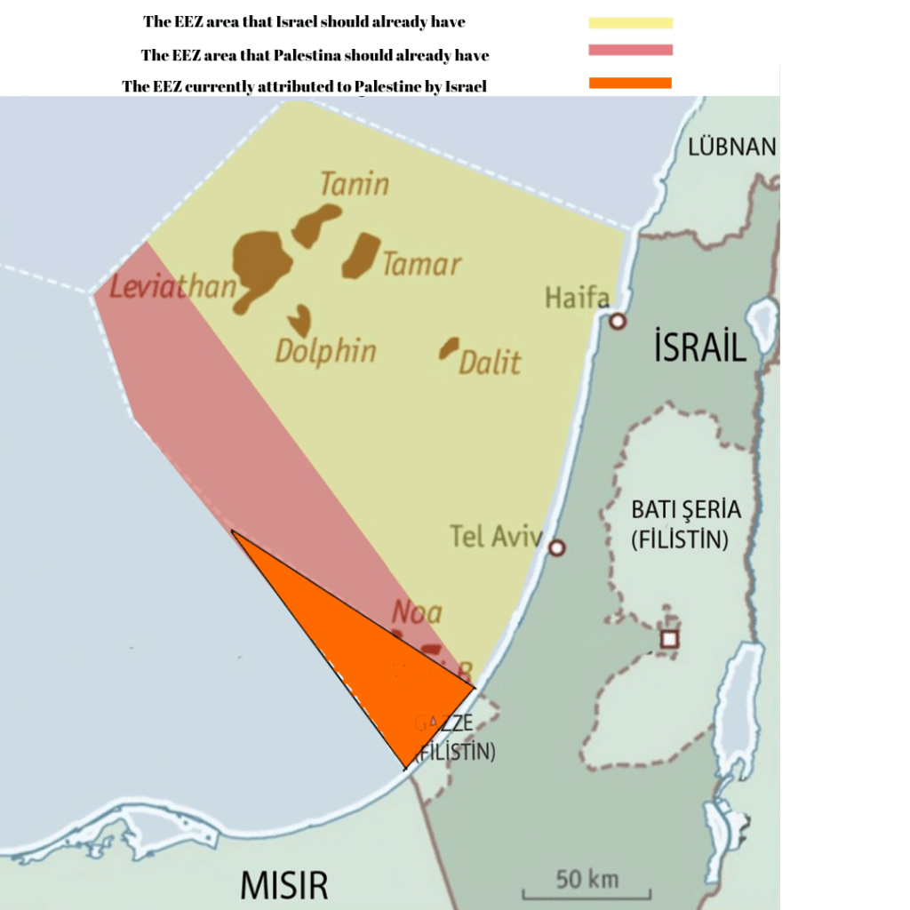
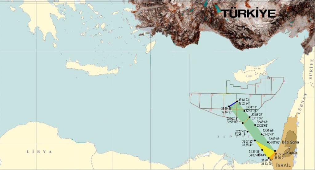
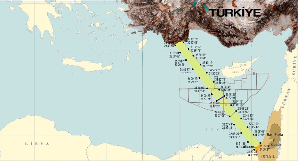
Turkey has a mutual coast with Libya and a mutual coast with Palestine. Now, our suggestion is that if a maritime jurisdiction delimitation agreement is signed between Turkey and Palestine based on the mutual coasts of Turkey and Palestine, Palestine will gain 8510 km2 more sea area and at the same time, Gazans will have a legal document in their hands.
Therefore, Israel has posed a threat to maritime security in the Eastern Mediterranean by occupying and denying the Palestinians the maritime jurisdiction areas arising from Gaza in its agreement with the SCGA, and now it has posed a threat to maritime security by wanting to occupy Gaza and take all maritime jurisdiction areas. The first threat in the Eastern Mediterranean is Israel’s actions and poses a threat to neighbouring countries. If this agreement is made, it will benefit both Turkey and Palestine in terms of Blue Homeland.
- Finally, Ansarullah is part of the axis of the Iranian resistance with access to two seas, the Mediterrane an through Hezbollah-Syria, to the Red Sea through the Yemeni coast controlled by Ansarullah. Are we facing the embryo of a possible projection? thalassocratic» of the axis of resistance once it has been stably imposed at the «tellurocratic» level from the Zagros to the façade of the Mediterranean, Red and Persian Gulf seas?
It would be much more accurate to answer this question from an ideological point of view. Since 1979, Iran has been trying to build a strong ideological influence in the Middle East.
It would not be correct to limit this situation to Ansarullah. For example, Al-Ashtar Brigades in Bahrain, Kata’ib Hezbollah in Iraq, Hezbollah in Lebanon, Fatemiyoun and Zainabiyoun Brigades in Syria, and of course Ansarullah, the armed arm of the Houthis in Yemen, are complementary elements of this ideological equation that Iran wants to establish.
This issue should not be evaluated on a sectarian basis because Iran is also trying to establish influence over Sunni groups in our region. The Persian Gulf, the Strait of Hormuz and the Red Sea axis are the geopolitical levers of this sphere of influence that Iran is trying to build. Iran is trying to dominate this area, which is a nodal point for global oil, but in another dimension, it is also trying to establish a safe route through which it can provide logistical support to its proxy forces in Africa. It should not be forgotten that Iranian-backed movements, especially in Nigeria and Mali, have gained serious momentum in the last 20 years. The ideological balance created here covers not only the Middle East but also Africa.
These are all imaginary threats and cannot be realized because neither Iran nor the so-called Iranian-backed groups have the power to do so. It is not possible for them to dominate such a large region. However, there is one thing that is possible. The establishment of a Greater Israel with the PKK, YPG, supported by a number of Western states, and the promised land project by acting together with Iran underhandedly is a very important threat to the region. These areas we are talking about are actually the target of Israel, not Iran. There is even a ministry in Israel that aims to obtain the promised land. Its name is the Ministry of Heritage. There is nothing more to be said.
- If this happen and the axi of resistance start a stable projection to sea and start activities in Mediterránean Sea. How does this affect Türkiye’s maritime security and the Mavi Vatan?
It is all about the greatest danger, as Biden and Netanyahu have said before, that the borders in the Middle East will be redrawn and nothing will be the same in the Middle East. The region is being dragged into chaos by destabilizing it, trying to change its borders through wars, and trying to draw a new map out of chaos. At this point, not only the borders of a number of states are likely to change, but also their destruction and disintegration. From this point of view, in terms of the Blue Homeland in the region, both the determination of maritime jurisdiction areas, the provision of maritime security, the protection of the blue economy and the maintenance of maritime transportation are subject to serious risks and dangers. At this point, the establishment of a maritime security joint platform with Turkey, Egypt, Palestine, Libya, Libya, TRNC, Lebanon and even Syria would benefit all countries in the region. The fundamental principle of the Blue Homeland is the principle of regional ownership, which means that the maritime security and sharing of the seas should be carried out by the coastal states and the intervention of extra-regional actors in the region should be prevented. Initiatives to be taken within the framework of the principle of regional ownership will not only lead to the establishment of good relations between the countries of the region, but will also result in the establishment of peace, stability and security in cooperation and coordination. At the same time, within the framework of the principle of regional ownership, which is the basis of the Blue Homeland Doctrine, the countries and peoples of the region will be able to benefit from the resources of the region. Therefore, I would like to reiterate that the signing of a maritime jurisdiction delimitation agreement between Turkey and Palestine would be a very important start. I would also like to emphasize the importance of the participation of other regional countries in the Operation Mediterranean Shield, which we are conducting in the Mediterranean under the leadership of the Turkish Navy. In agreement with Turkey, Libya gained 39.000 Km2 maritime jurisdiction area. Under a possible Palestine-Turkey maritime delimitation agreement, Palestine’s maritime area gain would be a minimum of 8,510 km2.
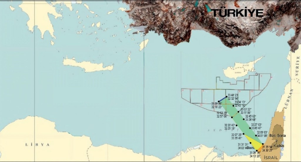
Map showing the EEZ that Palestine will have in the event of a treaty with Turkey and the current EEZ of Palestine (in yellow).
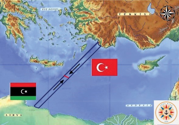
Map showing the mutual coasts of Turkey and Libya.
